

Abandonment (Abandoned) Well
A well that is shutdown permanently, since it has ceased to produce crude oil. Abandoment of a well should involve set procedures, that may vary depending on the nature of the formation and on individual juristiction's regulations. Abandonment usually involves cementing the well through important formations near surface, removing surface aparatus, and providing a cap on the wellhead.
Acid Stimulation
Acid stimulation -- or acidizing, or reservoir stimulation -- is the treatment of a reservoir formation by injecting substances that act as an acid to remove near-well damaging substances in order to improved oil or gas production.
Active Well
An active well is one that is currently in a process of producing oil or gas.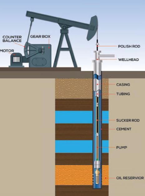
Alida Beds
Named after Alida Oil field, the Alida Beds are located in southeast Saskatchewan, 225 km from Regina, and have been producing oil since their discovery in 1955. The formation consists of two carbonate reservoirs that have a combined thickness of about 52 meters; the beds have been producing for over 40 years, and have had their lives extended with the advent of horizontal drilling technology.
Anhydrite
Anhydrite is an evaporite mineral that occurs in sedimentary basins and it is interbedded with halite, gypsum, and limestone; they occur in the geological record where large volumes of sea water have been evaporated.
Annulus
The annulus is the space between the casing and tubing in a well, or between the wellbore and casing, that allows for fluid to flow and cirulate in the well.
API Gravity
API (American Petroleum Institute) Gravity is used to measure the relative density of various petroleum fluids and how heavy or light they are. A low API number (under 10) means the liquid is heavy, often with an inability to flow, and more likely to sink. A higher API value (over 10) means the petroleum product is light and able to flow more easily.
Appraisal Well
An appraisal well is drilled to measure and determine the size, and the volume, of hydrocarbons in a reservoir.
Aquifer
An aquifer is a underground layer of permeable rock bearing water or other liquids. The term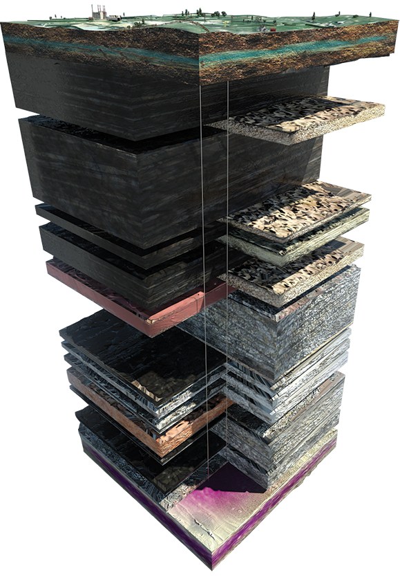 , in petroleum geology, can refer to any liquid-bearing zone in the subsurface. In relation to the PTRC's Aquistore project, the saline aquifer into which the CO2 is being injected is a permeable sandstone and brine formation 3.4 km underground. The opposite of an aquifer is an aquitard, which is a rock formation that is not permeable and does not contain or allow for the passage of liquids. In the image included to the right of the Aquistore geology, the layers on the left are aquitards, and those broken out on the right are aquifers.
Bakken Formation
The Bakken Formation occupies about 200,000 sq miles (520,000 sq ki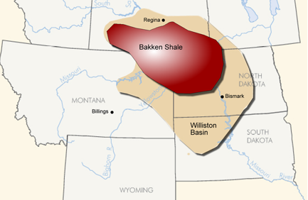 lometres) of the subsurface in the Williston Bassin, which underlying parts of Montana, North Dakota, Saskatchewan and Manitoba.
Battery
A battery in the oil and gas industry refers to a storage facility / collection point fo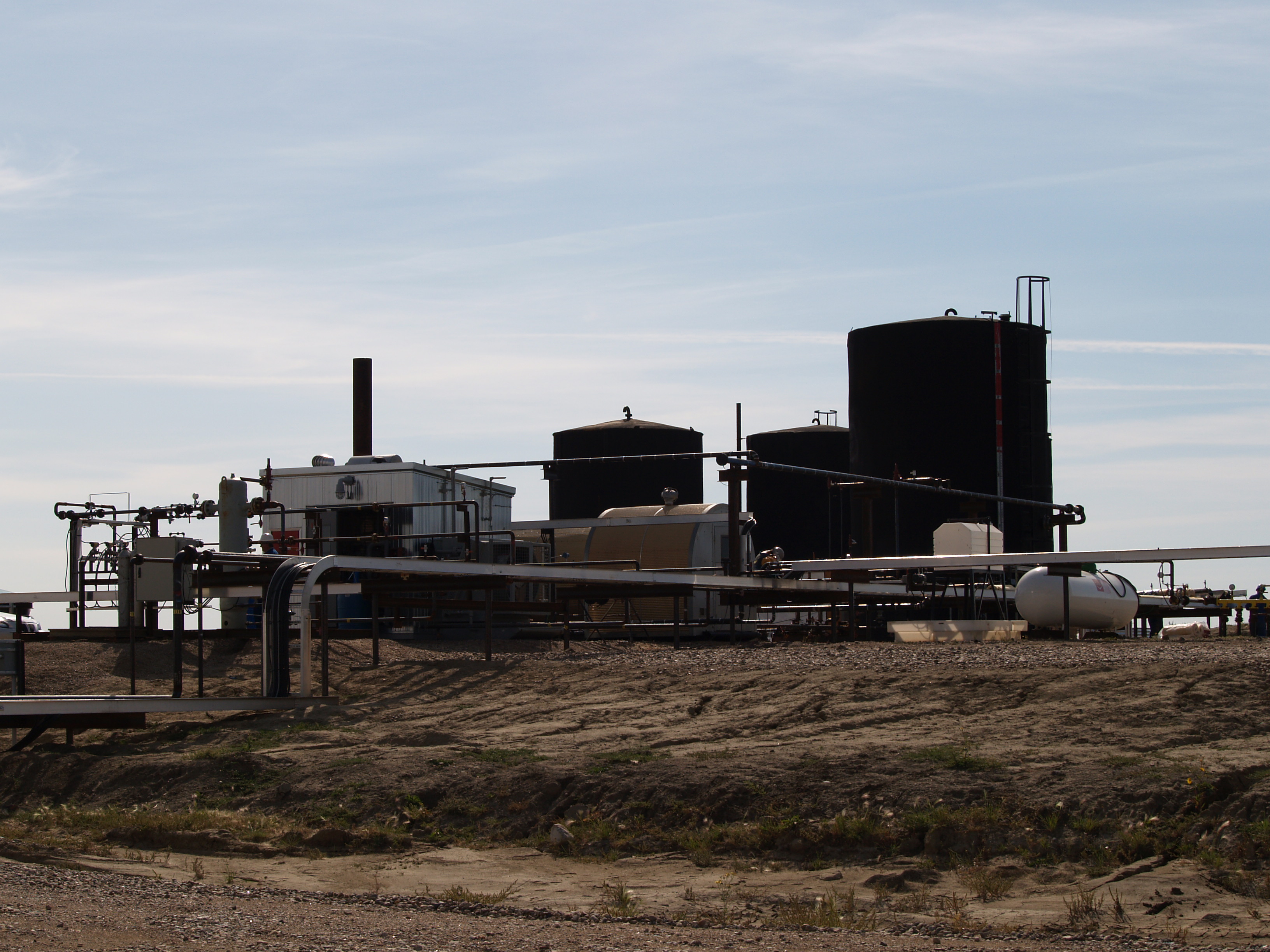 r fluid production from a well or group of wells, which measures and separates the oil, gas and water produced from those wells prior to delivery of the oil or gas to the market.
Birdbear Formation
The Birdbear Formation lies on top of the Duperow Formation and beneath the Three Forks Formation in the central part of the Williston Basin. Oil and gas have been produced from the Birdbear Formation in Saskatchewan and Montana since the early 1960s.
Bitumen
A naturally occurring semisolid organic matter in a reservoir containing hydrocarbons. Bitument has a very low API gravity and usually requires upgrading to synthetic crude oil or the addition of a diluent (natural gas) to flow to market..
BOED (Barrel of oil equivalent per day)
BOED is an acronym, meaning Barrel of Oil Equivalent per Day. The term is often used when oil or gas companies are measuring their production in square metres or feet, and want to translate those amounts into barrels per day.
Bridge Plug
Bridge plug refers to a downhole instrument that is used to isolate the lower part of the wellbore. It works as a sealing tool. Bridge plugs may be permanent or temporary. It enables a lower wellbore to be permanently sealed from production or temporarily isolated from a treatment conducted on an upper zone.
Bubble Point
The bubble point is the pressure reading within a reservoir at which the first bubbles comes out of the petroleum fluid. The bubble point is affected by pressure and temperature in the reservoir.
Cap Rock
Cap rock is an impermeable rock that forms a seal above the reservoir rock so that fluids cannot migrate beyond the reservoir. Cap rocks have very low porosity and permeability. Usually cap rocks are shale, anhydrite, or salt.
Carbon Capture and Storage (CCS)
Carbon capture storage (CCS) is a suite of technologies that combine to capture CO2 (carbon dioxide) from the atmosphere or from a set point source like a coal-fired power station, compress and transport that CO2, and then inject it deep underground into porous rock formations (either a deep saline aquifer, or a depleted oil/gas field). Visit the PTRC's Aquistore page for more information on the storage component of CCS.
Carbonate
Carbonates are a class of sedimentary rock mainly composed of calcium carbonate minerals.
Casing
The casing is steel pipe that is cemented into a wellbore to prevent the formation from collapsing or caving in.
Chemical Flooding
Chemical flooding is an enhanced oil recovery method that uses chemicals to reduce the surface tension between oil and water, allowing for more oil production than simple waterflooding. It is an EOR process used after the primary and secondary recovery.
CHOPS
CHOPS is an acronym that stands for cold heavy oil production with sand. It is a non-thermal method that was developed, along with cavity pump technology, in the 1980s to increase oil production from Saskatchewan and Alberta's heavy oil reservoirs.
Completion
Completion refers to steps taken to convert a drilled well into a production well, and includes the steps of casing, cementing, perforation, and gravel packing.
Condensate
Condensate is a high API gravity, low-density liquid hydrocarbon that is created in association with natural gas as pressure depletes.
Conventional Crude Oil
Conventional crude is an oil that can be produced easily using traditional drilling methods via the natural pressures in existence in the reservoir.
Coring
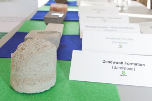 Coring is a term that refers to samples of rock taken from oil or gas wells for the purpose of examination to determine the characteristics of reservoir, and such features as permeability, porosity, etc. -- all of which will help determine what recovery processes are best for producing oil. Here, core samples taken from different geological layers during the drilling of the Aquistore well are on display.
Cumulative Production
The total amount of hydrocarbons produced from a reservoir over a specific period of time.
Cyclic Solvent Injection (CSI)
Cyclic solvent injection (CSI) is the use of different solvents, such as CO2 and Methane, for enhanced oil recovery (EOR). When a solvent is injected into an oil reservoir, it interacts with oil to lower its viscosity and make it more mobile within the formation. The thinning of the oil allows it to move towards the production well faster and, usually, at greater volumes resulting in an increased production rate. Most CSI technologies require a soaking period after the solvent is injected -- this can be several days or several weeks -- to allow the solvent to interact with the oil. One of the configurations in PTRC's pilot project JIVE included CSI.
Cyclic Steam Stimulation (also, Cyclic Steam Injection)
A thermal oil recovery method that injects steam into a reservoir. This injection is then followed by a period of soaking where the well is shut in for several days. The soaking period leads to a reduction in the oil viscosity, and the well is put back on production.
Dew Point
The dew point is the pressure point at which the first liquid comes out of solution in a gas condensate reservoir.
Directional Drilling (also, Horizontal Drilling)
Directional drilling in the oil and gas industry is drilling at an angle across the reservoir such that the well hits more targets across a the production zone, to improve the productivity of wells.
Dolostone
Sedimentary rock composed of magnesium-rich carbonate mineral.
Dominion Land Survey System (DLS)
Historically, the Dominion Land Survey System was imposed in the late 19th and early 20th Centuries in Canada, and divides western Canada into one-square-mile sections for petroleum and agriculture purposes.
Downstream Sector
Downstream oil and gas refers to the refining of crude oil, and the purifying the natural gas, including the marketing and distribution of products that are derived from both. This the opposite to Upstream, which refers to the exploitation/production of oil and gas (drilling, recovery).
Drill Stem Test
A drill stem test is a procedure conducted during drilling of a well. This test provides information on whether to complete the well. During the test, the zone of interest is sealed off from the rest of the wellbore by packers. The packers are set to isolate the zone from the drilling fluid column. The drill stem test tool is equipped with pressure recording devices. These devices measure and record pressure in the well while it is both flowing and shut in. The test allows the formation fluids to flow into the drill stem and to the surface. Drill stem tests provides information on the formation’s pressure, permeability, and hydrocarbon productive capacity.
The link below provides some background on drill stem tests from YouTube
Drilling Rig
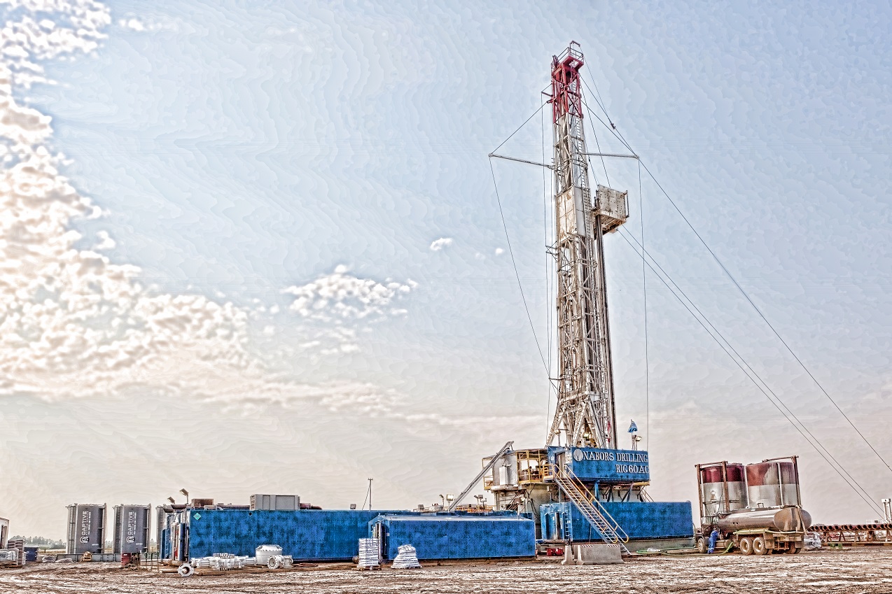 A large structure with the equipment to drill an oil, gas or injection well. Drilling rigs can be both onshore and offshore. The photograph here shows the rig that was used to drill the Aquistore CO2 injection well in July of 2012.
Electromagnetic Imaging (EM)
This technology allows well operators to image the deep subsurface around their wells by dropping an electrode down the length of a well, settling at various points in the subsurface where an image needs to be created. EM surveys measure conductivity in the reservoir through electromagnetic induction – different conductivities correspond to different substances. This technology has been used to find underground voids (spaces), oil and gas fields, and in the case of PTRC’s Aquistore Project, identify the CO2’s location in the Deadwood formation 3.2 km underground.
Emissions
Emissions refer to gasses that are released into the air from power plants and factories. These emissions may contain different gases, such as NOx and SOx, and are a particular focus of greenhouse gas mitigation efforts when they contain CO2 and methane.
Emulsion
A dispersion of one liquid into another immiscible liquid that will not separate into individual components.
Enhanced Oil Recovery (EOR)
Also called Tertiary Recovery, EOR is a method to extract hydrocarbons through thermal or chemical techniques by altering the oil properties, and to improve oil displacement.
Exploratory Well
A deep test well that is drilled onshore and/or offshore to discover oil and gas reserves after collecting seismic data.
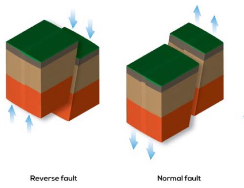
Fault Trap
 The area in a geological formation where the hydrocarbon flow is restricted by a sealed rock. Fault traps are often the geological formations (see image) that trap and seal hydrocarbons, and are often good oil production zones.
Fibre Optic Cable
Similar to an electric cable, a fibre optic cable contains one or more fibres that are used to carry information in the form of light. Fibre optic cables are able to carry and move large amounts of data, and to similarly record such information when attached to different recording devices. At the PTRC's Aquistore site, fibre optic cables are used to provide DAS (distributed acoustic sensing) and DTS (distributed temperature sensing) deep underground.
Fire Flooding (also, In Situ Combustion)
A oil recovery technique used to inject oxygen into the hydrocarbon formation, and then introducing combustion into the reservoir to lower the hydrocarbons' viscosity. A producing well then collects the heated production.
Flare Gas (Flaring)
The burning of an unwanted gas at a production facility or well head, which would otherwise get released into the environment, from a petrochemical, oil/gas battery, or processing plant.
Foamy Oil
In Saskatchewan and Alberta heavy oil fields, foamy oil is created when heavy oil is produced from reservoirs. Gas that is in the heavy oil, as the oil becomes depressurized at the wellhead, begins to come out of the solution and those gas bubbles get dispersed in the oil solution, making it foam and become more viscous. In effect, a heavy oil producer wants to induce foamy oil and keep the gas bubbles dispersed as long as possible as the reservoir begins to produce because the dispersion makes the oil flow more freely and increases recovery factors.
Formation
The geology and layers above, in and below a reservoir that need to be characterized prior to drilling a well.
Fossil Fuel
Fossil fuels include oil, natural gas, and coal, which were created in the geological past from the remains of living organisms.
Fracking
A stimulation process designed to enhance oil and gas productivity. The process involves pumping fluid and sand into an oil or gas formation deep underground, along a horizontal well, and then introducing pressure or small charges that cause fractures within the reservoir. Those fractures allow for the drainage of hydrocarbons into horizontal producing wells.
Frobisher Beds
The Frobisher beds and Frobisher oil field are located in southern Saskatchewan, and consist of oolitic and pisolitic carbonates, sandy dolomite and dolomitic limestone. The thickness varies from 43m to 70m.
Fugitive Emission
Fugitive emissions refer to gases or vapors that leak from production facilities, wells/wellheads and pipelines. They are irregular releases of gas that need to be eliminated through various mitigation technologies.
Gas-to-Oil Ratio
This ratio measures the volume of gas that comes out of solution to the volume of oil, at standard conditions.
Geological Model
Geological model is a computerized representation of portion of the earth’s crust based on geological and geophysical data. Geological models provide a static description of the reservoir.
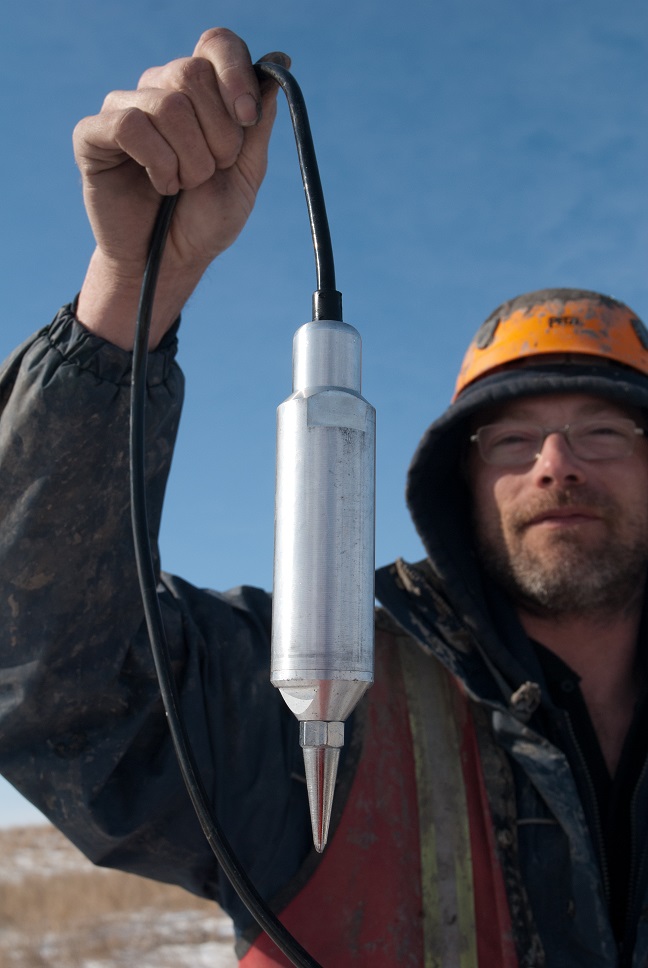
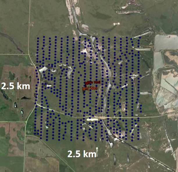
Geophone
Geophones are acoustic detectors, or listening devices, that repond to ground vibrations and convert that energy/movement into voltage, which is then sent to a recording station such as a seimometer or other listening device. Geophones are used in different industries, including oil & gas and mining, to convert waves that are created from small dynamite charges (or from vibroseis vehicles) into visual images of what is happening deep underground. At the PTRC's Aquistore project, 630 geophones are arranged into a 2.5 km by 2.5 km square grid in order to help image the injected CO2 over 3 km underground.
Geothermal Energy (Electricity)
Geothermal energy refers to heat production originating in the earth that is used for various energy purposes -- everything from the heating of buildings and hotsprings through the cycling of hot water from reservoirs (in locations like Banff or Jasper), to the production of electrical energy through the creation of steam to power turbines. Most sources of geothermal energy and hot water are volcanic in orgin, but can occur at particular depths across the globe where aquifers are under pressure. In Saskatchewan, various formations contain water hot enough to potentially exploit for electical generative purposes, including the Deadwood formation where Deep Earth Energy Prouduction (DEEP) is currently conducting a pilot to generate electricty from hot brine from a depth of 3.4 km.
The same Deadwood formation is the location of PTRC's Aquistore CO2 storage project, and PTRC is studying the possiblity of CO2 in the reservoir being used to bring heat to the surface in a geothermal configuration.
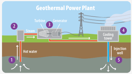
Source: https://archive.epa.gov/climatechange/kids/solutions/technologies/geothermal.html
Gravimeter
A gravimeter is an instrument used to measure gravitational force, and changes in gravity due to the deformation of the earth. In the case of the Aquistore project, gravimeters are used above the CO2 injection site to measure minute changes in gravitational force arising from the increasing totals and concentrations of CO2 in the storage reservoir 3.2 km underground. In the oil & gas and mining industries, gravimeters are used to help measure the gravity field of different locations in space and time, in order to help predict the location of certain kinds of geologic formations and substances, like oil or water.
Gravity Survey
Gravity survey is measuring gravitational changes at a series of different locations over an area in the well. Variation in gravitational field is due to mass changes, fluid distribution and density changes of the rocks. At Aquistore CO2 storage project, gravity surveys measures density changes due to CO2 substituting the formation water. Injection of CO2 into an aquifer displaces higher density formation water and produces a lower density plume growing outward from the injection well.
Heavy Crude Oil
A very viscous oil that is unable to flow to the production well under normal reservoir conditions. Heavy oil recovery usually involves the addition of heat or solvent to lower the oil's viscosity.
History Matching
History matching is the process of building a set of models which includes information about the reservoir geology and past production data. The model is used to simulate future reservoir behavior with higher degree of confidence.
Horizontal Well
When the shape and formation of a reservoir makes producing oil or gas difficult to access with a conventional vertical well - either because of the tightness of the reservoir, or because the pay zone of the reservoir is extremely narrow and spread out laterally across the area - horizontal wells can make accessing the resources contained in the reservoir easier and more efficent. Horizontal wells, as the name suggests, move horizontally (across) a reservoir, creating several possible contact points within the formation where oil or gas can be extracted, rather than the single location offered by a traditional vertical (up and down) wellbore.
Many horizontal wells in tight oil formations are coupled with hydraulic fractures at various points over their lengths, which allow for oil to flow to the wellbore and be pumped to surface. Horizontal wells can also be used to inject substances like solvent or water, to help improve oil recovery.
An illustration of horizontal wells, used in the PTRC's solvent injection pilot project called JIVE, can be found in the animation below.
Hydrocarbons
A molecule made up of carbon and hydrogen atoms. Many of the fuels used on daily basis for transport and heating consist of hydrocarbons.
Hydrogeology
Hydrogeology (hydro - meaning water and geology - meaning the study of the Earth) is the area of geology that deals with the study of ground water (both near surface and deep surface in saline aquifers or other formations). At the Aquistore CO2 injection site, hydro chemical groundwater assessment of the site - both near the surface and at over 3 km depth in the Deadwood deep saline aquifer - provides a framework to assess changes in hydrological properties specifically related to the presence of injected CO2.
Improved Oil Recovery
See Enhanced Oil Recovery.
In Situ
In Situ is a Latin term meaning "in position" or "on site". When used in relation to oil sands, "in situ oil sands extraction" means oil sands production that is done in place (e.g. through injection of steam or solvent deep underground and drawing the oil to surface without disturbing the sand). Ths is the opposite of "mined oil sands", which require the sand to be moved from its location to processing facilities where hot water is introduced to strip off the oil.
In Situ Combustion (see also, Fire Flooding")
The methods of thermal recovery where fire is generated into the reservoir by injecting oxygen. As a result, the heated and combusted part of the reservoir creates a front where the remaining hydrocarbons are pushed to the oil to the production well.
Inactive Well
A well where production, injection, disposal or workover operations have been ceased, but permanent abandonment has not taken place.
Infill Wells
An infill well refers to the addition of a well(s) in a field to decrease the average well spacing, in order to increase the recovery in the reservoir by improving the continuity between injector and producer wells. In simple terms, in fill wells (like the name suggests) increases the number of wells in a select area where wells already exist.
Injection Well
A well where fluid or gases are injected into a reservoir to maintain the reservoir pressure and to maintain an effective recovery factor.
Isothermal Process
In thermodynamics, an isothermal process is one in which the temperature of the system is constant, as represented by:
ΔT = 0
Joint Implementation of Vapour Extraction (JIVE)
JIVE was a field pilot program begun at the PTRC in 2005, running until 2011, involving four depleted heavy oil fields in Saskatchewan and Alberta. Different solvents (methane, butane, and propane) were injected into these fields, using various injection configurations, to see if enhanced oil recovery would result.
The research program was funded by Western Economic Diversification, the Government of Saskatchewan, and three oil companies (Nexen, CNRL and Husky) each of which provided access to the oilfields to conduct the injection experiments. Much of the research was conducted by the Saskatchewan Research Council's Energy Division. Aside from the main goals of improved recovery from the reservoirs, participants were also encouraged by reductions on CO2 emissions during the extraction processes because of the use of solvents rather than steam. Converting steam-assisted gravity drainage to solvent extraction resulted in reduced CO2 production because the burning of natural gas for steam production was eliminated.
Results also highlighted challenges related to the economics of solvent recovery during oil production. The more solvent that returned with the oil, the better the economics since it could be re-used in future injections. This solvent injection field trial also set the stage for Husky Energy's ongoing use of CO2 injection in heavy oil fields. For a full explanation of the field trials visit the JIVE page by clicking on the logo below.

Jurassic Period
The Jurassic is a geologic period that spanned from the end of theTriassic period 201.3 million years ago to the beginning of the Cretaceous period 145 million years ago. The Jurassic is the middle period of the Mesozoic Era. Many new dinosaurs emerged during this period. It was an era with a wet, warm climate.
The period is marked by the breaking up the the super continent, Pangea, and the flourishing of many different land and sea dinosaurs. The Icthyosaurus image below is from Wikipedia.

Lease
An agreement between a company or an individual with a mineral rights owner granting permission to that company to search and produce possible hydrocarbons on the right holder's land.
Light Crude Oil
A crude oil that has an API gravity of more than 40.
Limestone
Sedimentary rock mainly composed of calcite mineral.
LNG
Liquified Natural Gas.
LPG
Liquefied Petroleum Gas.
Manville Group
The Manville Group consists of interbedded nonmarine sands and shales in the border region between Alberta and Saskatchewan. The thickness of the Manville Group is about 145 meters and is found through the Vermilion area of Alberta, and has been accessed in the Athabasca, Edmonton, and Lloydminster areas.
MBBL
MBBL means thousands of barrels. For example, 20 MBBL oil means 20,000 barrels of oil.
MBOE
MBOE means Thousands of Barrels of Oil Equivalent.
MCF
MCF means Thousands of Cubic Feet. It is a standard measurement used in the United States for natural gas production. Other countries use metres, not feet.
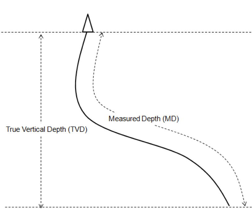
Measured Depth
Measured depth (MD) is the total length of the wellbore measured along the actual well path.
Medium Crude Oil
Oil with an API gravity in between 31-33.
Microbial Injection
An enhanced oil recovery process in which microorganisms are used in a reservoir to improve oil recovery by injecting the microbes into the reservoir, or just by enhancing the population of microbial activity already in the reservoir by injecting nutrients.
Midale Beds
The Midale Beds took its name from the Midale oil field in southeastern Saskatchewan. The thickness of the Midale Beds varies from 15m to 45m. It is a major oil producing formation in Saskatchewan.
Midstream Oil and Gas
One of the three major stages of oil and gas industry operations which includes the processing, sorting, transporting and marketing of oil and gas. See also Upstream and Downstream Oil and Gas.
Mineral Rights
Mineral rights refer to the ownership of resources that rest beneath a piece of land. That may include oil, gas, potash, lithium, and metals. Possessing mineral rights for a property means that you are able to be paid for the exploitation of those resources, athough the costs associated with accessing those resources may be prohibitive. This reality usually means that mineral rights holders will negotiate a royalty with companies that have recieved the rights from the government to develop resources in a particular part of the province. Royalty rates are paid to mineral rights holders based on a negotiated amount from the explotation company.
The Government of Saskatchewan has "land leases" each year where access to different resources are put up for bids from different exploitation and exploration companies. Individual mineral rights holders in that leased area may negotiate for royalty payments from the companies that win the rights to develop the resources.
Owning property does not guarantee that you own the mineral rights beneath. In Saskatchewan, only about 22% of land owners possess the mineral rights beneath their land.The rest is owned by the Crown (provincial government) or by previous owners of the land who decided not to hold on to the mineral rights when they sold the property. For more information from the Government of Saskatchewan, click on the image below.
|
|
Mississippian
A subsystem in the geological timescale, the Mississippian is the lowermost of the two geological subperiods in the Carboniferous period. It is named after the Mississippi River Valley.
MMBL
MMBL means million of barrels of oil. For example, 20 MMBL means 20 million barrels of oil.
MMCF
MMCF means Millions of Cubic Feet. This is a standard unit of measurement used in the United States for oil and gas production.
Monte Carlo Simulation
Monte Carlo simulation is a mathematical model used to predict the probability of different outcomes when there are different variables in play. It helps to make decisions and provides a range of possible outcomes. It explains the impact of risk and helps with forecasting.
Oil Sands
A porous rock layer considered to be a mixture of sand, clay, water and bitumen. Both Alberta and Saskatchwan have oil sands deposits, but only Alberta's are recoverable using existing extraction technologies. Signficiant oil sands deposits also exist in locations such as Utah in the United States, and in Venezuela and Colombia in South America.
Original-gas-in-place (OGIP)
This term refers to the total amount of gas (in most cases natural gas, or methane) that exists in a reservoir. Not all the gas in a reservoir is necessarily producible, and this term recognizes what volumes of a gas exist in a reservoir, but not necessarily what will eventually be recovered. Actual recovery will vary depending on such things as the tightness of the reservoir, how deep it is, and what technologies are available.
Original-Oil-in-Place (OOIP)
Original-Oil-in-place refers to the volume of oil in a reservoir prior to the beginning of production. The term is different than "reserves" in a reservoir in that oil-in-place includes recoverable and non-recoverable oil, whereas "reserves" refers only to the recoverable oil in a reservoir. As an example, the Alberta oil sands have 2 trillion barrels of original-oil-in-place, but only 175 billion barrels of those are considered recoverable "reserves".
Ozone
A Colorless toxic gas formed from oxygen by an electrical discharge.
Pay Zone
The portion in a reservoir that contains an economically producible hydrocarbon.
Perforation
A hole in a casing or a liner that is created through the use of a perforation gun (hole producing gun) that allows oil and gas to flow into a production well and eventually get produced at surface.
Permeability
The ability of a rock to transmit fluid, which is measured in Darcie’s or millidarcies. A rock may be porous (filled with microscopic pores and holes) but have no permeability (connections between those pores that allow for the flow of liquid). When an oil field lacks permeability it is sometimes referred to as a "tight' oil reservoir that requires some level of fracking to produce.
Petroleum
Naturally occurring hydrocarbon compounds found in rock
Petrophysics
Petrophysics is the study of physical and chemical properties of rocks and the way they interact with fluids. Petra means rock and physics means nature in Greek language. Petrophysics analysis is used at the Aquistore CO2 storage site to characterize the reservoir.
Polymer Flooding
An enhanced oil recovery technique that introduces viscous water into the oil, through a soluble polymer (large molecules created from monomers) that helps create a miscible solution, which allows oil to flow more freely to production wells.
Poplar Beds
These beds are named after the Poplar Beds located in Montana, and have produced oil from several relatively thin carbonate layers. The beds cover about 12950 km2 in southeastern and south-central Saskatchewan, with average bed thickness in Saskatchewan of about 117m.
Porosity
A measurement of the void space in a rock. See also the description of Permeability for an understanding of how porosity differs from it.
Possible Reserves
An estimate number of hydrocarbons that maybe be available for extraction in a oil bearing formation/reservoir, using existing equipment, and under existing conditions.
Potash
Potash is found in the vast majority of Saskatchewan, which has the world’s largest reserves of this fertilizing mineral. It is most often found approximately 1000 meters below the earth's surface. It is mined in two ways: (1) either indirectly through the injection of water to dissolve the potash and bring it to surface, or (2) physically through mining using tools and direct man power. See also Prairie Evaporite.
Prairie Evaporite
A geological formation across much of Western Canada and the states of Montana and North Dakota. In Saskatchewan, it covers most of the south and central of the province. It consists of halite, carnallite, and sylvite of various hues and degrees of crystallinity. The maximum thickness of the formation is 218m. The Prairie Evaporite is a main souce of Potash for the province of Saskatchewan.
Pressure Build-up Test
A pressure build-up test is usually conducted at an oil well where constant production is occuring; the well is suddenly shut in so operators may measure how the bottom hole pressure at the well is building back up. The objective is to determine reservoir properties such as pressure, flow capacity, permeability, and skin effect.
Pressure Drawdown Test
A pressure drawdown test is a series of bottom hole pressure measurements made during a specific period of a well's operation with constant production rate. The objective is to determine reservoir characteristics such as permeability, skin effects and the radius of investigation.
Primary Recovery
The first stage of oil and gas recovery where oil and gas extraction relies on the natural pressures in the reservoir to produce oil and/or gas.
Produced Water
The water that comes to the surface and is produced as a by-product of oil production from a reservoir.
Proppant
A solid material that is used to keep an induced fracture open in a reservoir, such as sand and/or ceramics.
Pumpjack
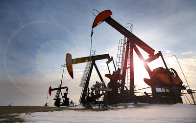 A pumpjack is used in the oil and gas industry to extract crude oil through artificial lift, which creates pressure in the wellbore to draw the oil to the surface.
Ratcliffe Beds
The Ratcliffe Beds are located in Southern, and south-central Saskatchewan. The average thickness is about 46m, and further south it goes up to 80m. This is a major oil producing zone in the province.
Recompletion
Completion refers to steps taken to convert a drilled well into a production well and includes the steps of casing, cementing, perforation, and gravel packing. Recompletion is when a well is losing production from the zone of interest and operators target other formations to improve the production inflow. Recompletion plan may include replacement of underground pump, motor or tubing, additional perforations, hydraulic fracturing, etc.
Recovery Factor
The percentage of oil recovered from a reservoir. It is usually calculated by dividing the total oil production by the total oil reserves.
Red River Formation
The Red River formation extends throughout the Manitoba outcrop belt. The formation consists of a basal fossiliferous, mottled dolomitic limestone overlain by a cherty dolomite. In the southern end the belt formation is about 150m, and thins to less than 50m towards the north. At the central part of Williston Basin it reaches up to 215m.
Reserves
An estimate of how much oil can ultimately be recovered for the oil-in-place within a reservoir.
Reservoir Modelling
Reservoir modelling is the construction of a computer model of a reservoir to help with decision making and evaluating different scenarios. Models could be 1D, 2D or 3D. There are two categories of reservoir models. Geological models and Reservoir simulation models.
Reservoir Simulation Model
Reservoir simulation model is used to simulate and predict the flow of fluids within the reservoir over a certain period.
Reservoir Stimulation
A process or number of processes that are used to repair formation damage or improve reservoir productivity. This includes processes such as hydraulic fracturing and matrix acidizing.
Saturation (pore saturation)
In relation to oil and gas reservoirs, and to deep saline (brine) aquifers, saturation refers to the volume of pore space (usually expressed in percentages) that is occupied in a formation. A high saturation percentage would indicate little available space in the reservoir, wheres low saturation would indicate the availabilityfor injection of fluids (such as super-critical CO2). Saturation levels are often tied to pressures and fracture potential within a reservoir, and geologist monitor both when injection is occuring.
Secondary Recovery
The process of injecting a fluid to maintain reservoir pressure is called secondary recovery. The most common techniques are gas injection or water flooding.
Seismic Sources
A seismic source is a device that generates seismic energy (vibrational and/or sound waves) that go down into the ground and return to surface, in order to be measured by listening devices like geophones. Seismic sources help create a measurable and visible image of objects and formations deep underground, like in the PTRC's Aquistore project, which uses different seismic sournces like ACROSS, vibroseis vehicles, and dynamite charges, to create such waves. The image below is of the ACROSS technology, a permanent seismic source from the Japan Oil, Gas and Metals National Corporation (JOGMEC) which has been testing the technology to help image the CO2 plume at the test site.
Seismic Survey
A method used by geophysicist and geologists to produce a picture of the earth's subsurface by sending reflecting waves (usually through small dynamite charges of vibroseis vehicles) into the earth, and recording the return of those waves using listening devices such as geophones connected to computers and software. Seismic waves move at different speeds depending on the material they are passing through, and an image of compounds within different stratigraphic layers of the earth is created through the recording of seismic waves and they return to surface.
Industry uses seismic surveys to search for deposits of oil, gas, potash and other minerals deep underground. At the Aquistore project, seismic surveys are used to image and monitor the CO2 plume as it expands in the deep saline reservoir 3.2 km underground. Please see the PTRC movie below.
|
|
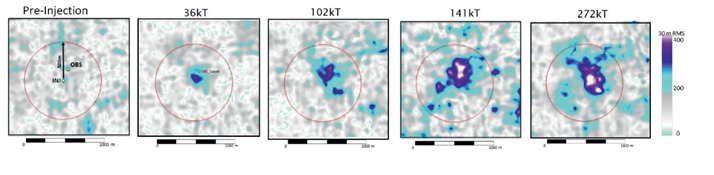 The completed seismic shoots done at various CO2 injection totals at Aquistore.
Seismometer
A seismometer is an instrument with a pendulum, or a mass mounted on a spring to measure and record low frequency ground movement or seismic waves. At the Aquistore CO2 storage site, seismometers are utilized to monitor any ground movement that may be associated to the injection of CO2.
Shale Oil
A crude oil that lies between layers of shale rock. Shale is a fine-grained sedimentary rock with very low permeability. This oil can be recovered through the process of fracking.
Shaunavon Formation
The Shaunavon is located in south-western Saskatchewan; in the Williston Basin it appears in Montana and North Dakota. The formation thickness is about 48 meters.
Skin Effect
Skin effect is a measure of the amount of damage or improvement to an oil & gas formation near the wellbore. It is a dimensionless quantity and can be zero, positive or negative. A positive skin effect indicates there is extra flow resistance near the wellbore. Improvement can be accomplished by acidizing and/or fracturing the reservoir to increase effective permeability. A positive skin effect indicates flow enhancement near the wellbore. A negative skin effect implies the presence of reservoir heterogeneities such as fractures that are impeding production at the well.
Click on the youtube video below for a full explanation of "skin effect" in oil and gas wells.
Solution Gas
A natural gas which is dissolved in the reservoir along with crude oil.
Sour Gas
Any gas that contains hydrogen sulfide (H2S).
Souris Valley Beds
These beds lie below the Tilston Beds in the Souris Valley (southwestern Saskatchewan) and are comprised of a dark grey, sparsely fossiliferous, thin bedded basin-type sequence of argillaceous limestones, calcareous shales, and chert. Souris Valley has not produced any oil and gas due to not containing any positive topographic features.
Steam Flooding
Also referred to as Steam Injection. This is a process in which steam is injected into a reservoir, increasing the temperature of crude and reducing its viscosity. The process also creates a sweeping efficiency and pushes the oil towards the production well.
Steam-Assisted Gravity Drainage (SAGD)
A process that involves two horizontal wells parallel to each other. The top well injects steam which lowers the oil viscosity such that is flows to the lower production well.
Stratigraphy
A branch of geology concerned with the study of rock layers; the term is also used to refer to the layers of rock themselves.
Surfactant
Surfactants (surface active agents) are compounds that reduces the surface tension between the two liquids, between a gas and liquid and between liquid and solid. Surfactants are used as cleaning products due to their ability to lower the surface tension of water, making molecules slippery so that it is more likely to interact with oil and grease (ex. Detergents and hand soaps) . Surfactant’s flooding is a type of chemical flooding used for enhanced oil recovery. They improve the wettability of porous rocks by reducing interfacial tension and allow water to flow through porous rocks faster which results in displacing more oil.
Suspended Well
A well in which operations have been discontinued for an indefinite period.
Sweet Gas
A natural gas (methane) that does not contain hydrogen sulfide. Sweet gas in a pure form of methane that can be used with little refining.
Tertiary Recovery (see also Enhanced Oil Recovery)
Another term for enhanced oil recovery. Tertiary recovery involves the extraction of oil that is not accessible from the natural energy/pressure of the reservoir. This extraction is usually performed by injecting a fluid.
Thermal Recovery
A process where heat is introduced into a reservoir. This process reduces the viscosity and increases the mobility of the oil, which improves recovery.
Tight Oil
When light oil is present in low permeability formations such as shale or tight sandstone, it is referred to as "tight oil". This oil is usually recovered through fracking.
Tilston Beds
Named after Tilston oil field near Tilston, Manitoba. The thickness varies from 49m to 80m. It is divided into two portions MC1 and MC2, MC1 consist on of oolitic-pisolitic, and grinodial grey stone. MC2 consist on argillaceous limestone or dolomitic limestone.
True Vertical Depth
True Vertical Depth (TVD) is the vertical depth of the well from surface to the bottom of the borehole. Usually, TVD is less than the measured depth. TVD is used to calculate hydrostatic pressure.
Unconventional Oil and Gas
This term refers to resources that cannot be explored and produced by conventional means. Examples of unconventional oil include oil sands, tight oil and shale oil. These use unconventional processes like fracking and SAGD.
Underbalanced Drilling
A process of drilling oil and gas wells in which the wellbore pressure is kept lower than the static pressure as the well is drilled.
Upstream
One of three operational stages in oil and gas (see also midstream and downstream). Upstream includes all the processes in the exploration and production of oil and gas (drilling, extraction, etc.).
Vapex (also, solvent vapour extraction)
A non-thermal heavy oil recovery method (Vapex is the commercial term for Solvent Vapour Extraction). Two horizontal wells are placed at a certain distance on top of each other. A solvent vapor is injected through the top well and that solvent reduces the oil viscosity. Oil is then produced through the bottom well.
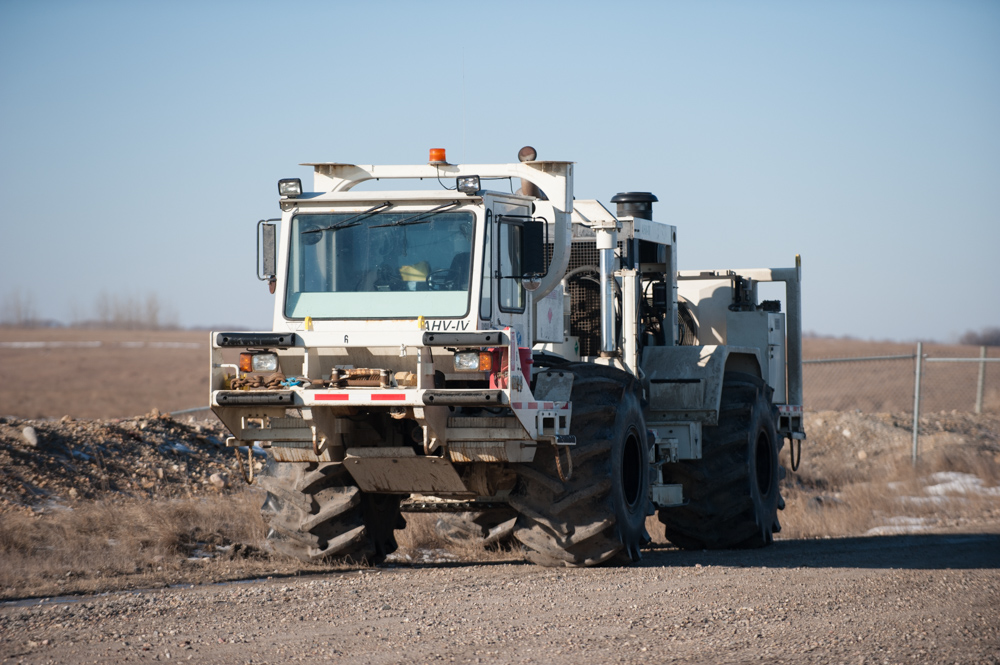
Vibroseis Vehicle
A vibroseis vehicle has a similar look to an 'earthmover' (see image below) and is specially equipped with large, heavy vibrators that provide a seismic source during land seismic surveys. The vibrator consists of a piston pressing against a steel plate, which is held against the ground by the weight of the vehicle. The rapid vibrations created by the vehicle are sent down into the ground and return to the surface after having passed through different geologic layers in the earth; the measurement of those returning waves allow for the creation of seismic images that reveal the composition of those different geologic layers. Seismic surveys utilize Vibroseis trucks to receive signals from these vibrators during monitoring through different monitoring technologies located at the surface, such as geophones, distributed acoustic sensors, etc. Vibroseis trucks are considered a safer and, often, less expensive source of waves than other seismic sources such as explosives. They leave little-to-no footprint on the environment.
Viscosity
Viscosity is a measure of a fluid's consistency and deformation. i.e. honey has a higher viscosity (thickness) than water.
Waterflooding
Waterflooding is a process where water is injected into an oil field such that the water pushes the oil to a producer well, increasing the recovery factor.
Waterous Formation
A stratigraphical unit formed in the Triassic to Jurassic ages located in the western Canadian Sedimentary Basin.
Well Integrity
Well integrity is attained when a well has been drilled and maintained properly, with the application of technical, operational, and organizational solutions to reduce any risk of uncontrolled release of formation fluids throughout its life cycle. Integrity is maintained through monitoring of the surface, including soil and ground water around the well, and by properly enclosing the well, usually through proper cementing and abandonment procedures, after its productive life is over.
Well Logs
A well log provides measurement of particular physical properties versus the depth of a drilled hole.
Well Reclassification
Reclassification refers to when a modification is made to a well that will either change the product a well is producing or the role of the well. For instance, changing a gas-producing well into an oil producing well or changing an observation well into an injection well or altering a monitoring well into oil producing well.
Well Test
Any acquisition activities conducted at a newly drilled well that allow for the collection of properties and characteristics underground in the reservoir that will identify its capacity to produce oil and gas. These might include pressure testing, production runs, flow tests, porosity and permeability tests, etc.
Wellbore
A hole that is drilled for exploration and recovery of natural resources from underground. It can be encased with materials such as cement and steel.
Western Canada Sedimentary Basin
A sedimentary basin underlying 1,400,000 kilometer of western Canada, including southwestern Manitoba, Saskatchewan, Alberta, and northeastern British Columbia, as well as the southwest corner of the Northwest Territories. The formation contains various kinds of sedimentary rock that may include hydrocarbons.
Wet Gas
Any gas with a small amount of liquid present (usually water).
Williston Basin
A large sedimentary basin rich in petroleum and potash that runs beneath eastern Montana, western North and South Dakota and southern Saskatchewan. The image here shows both the Williston Basin and the Bakken Formation overlying it.